11. Poll Ifrinn, Windfield Lower.

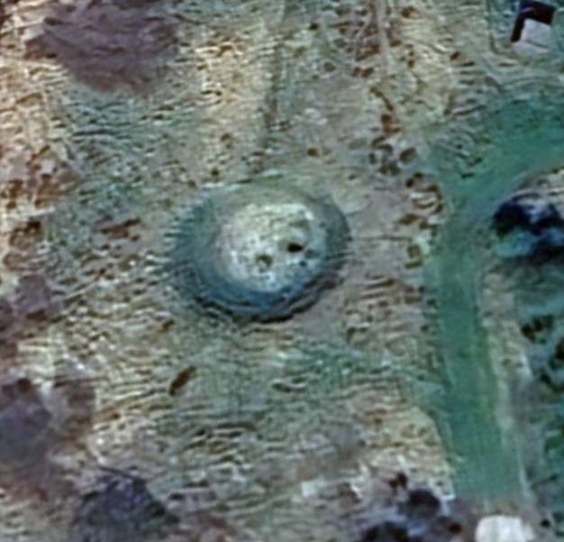
Pollifrinn, Windfield Lower.
In 1640 this area was known as Turloghgarrandana as recorded in the Down Survey. This translates as ‘the turlough in the copse’ where a turlough is a low-lying area on limestone which becomes flooded in wet weather through the welling up of groundwater from the rock, while a copse is a dense wooded area of either low growing trees or bushes growing in very close proximity to each other. The definition comes from the area known as Polliffrin, translating as ‘hell’s hole’ and this is located nearby. It is referenced and recorded in the first six inch ordnance survey maps of 1830s. Local folklore has always held that this is a bottomless mass of water, hence leading to hell.
The following article is reproduced from a collection of folklore compiled by schoolchildren in Ireland in the 1930s. This is a contribution by Katie Concannon, of Windfield Lower, as part of St. Joseph’s National School, Ballinruane, submissions. Katie received this information from her father, Thomas Concannon.
“In the West end of the Windfield demense is a spring called “Poll Eifrinn” the source of the Blue River. It was often tested in ancient times to find a bottom, but never could be found. The water is so clear that it has a blue shade. It is springing up at the rate of a million gallons a minute. The pit is about sixty yards long and sixty yards wide. There was a canal cut about three years ago into Poll Eifrinn but is unable to take the water. Poll Eifrinn is hell’s hole.
There is another pit called Poll Deamhall and another supposed to be the pit for the damned. On a sunny day, if you stand on the brink and throw in a white stone you can see it going down, down until it seems to go in under the brink.”
No Comments
Add a comment about this page